Sloat Restoration through Managed Retreat

Sloat Restoration through Managed Retreat
This is our original vision for Sloat Restoration - graphic courtesy of PSA and Associates and the Ocean Beach Task Force

Our Vision of Beach Restoration and Preservation

The shorelines of Ocean Beach south of Sloat Blvd and Sharp Park in Pacifica are threatened by rip-rap seawallls and long-term erosion. This blog chronicles our campaign efforts to restore these beaches. Check out the web view of this site to see our proposed solutions and how to help- in the right hand column below. For all the latest about our efforts, see our monthly posts.

We advocate a managed retreat strategy to restore both Ocean Beach south of Sloat and Sharp Park.

At Sloat, our vision involves:

A long-term plan to relocate threatened infrastructure
(including the south of Sloat Great Highway, the two oceanside parking lots and the sewer lines underneath them).

The cleanup of all the rock and rubble littering the beach.

The use of sand dunes as the primary tool to slow erosion.

For Sharp Park, we advocate the decommissioning of the golf course, the removal of the rip-rap berm, and a full restoration of the wetland.

Showing posts with label Coastal Erosion. Show all posts

Friday, April 6, 2012

A Wave of Media Attention on Sloat


Above: The inside sandbar at Sloat - under threat of backwash from an armored shoreline.

Dear Surfriders and Friends,

While we await the unveiling of the SPUR Ocean Beach Master Plan, there has been a groundswell of media attention on the Sloat issue. On Sunday March 23rd, the New York Times ran an article about Sloat on its front page. The next morning, the story was mentioned on NPR. On Tuesday March 25, KALW 91.7fm featured Sloat in the news program “Crosscurrents.” Today, the story made the front page of the San Francisco Chronicle. See links to these pieces on the right side of this page.

Overall, the coverage has been excellent. We are certainly happy to see the spotlight drawn to the issue. However, there is one important aspect to the Sloat story that seems to be consistently misrepresented. This has to do with the nature of the managed retreat approach and the fate of the Oceanside Treatment Plant. All too often the coverage paints a picture as if managed retreat implies the immediate and complete relocation of the entire sewer infrastructure - including the treatment plant. This is a most unfortunate characterization.

Our vision of managed retreat involves an immediate pull back of the southbound lane and Lake Merced Wastewater Tunnel only. By relocating these two items, clean up of the rock and rubble may commence. The treatment plant itself is apparently in no immediate danger. Presently it is protected by the 2010 revetment as well as a rather large coastal bluff. Ultimately, we advocate aggressive beach nourishment to address the issue of the plant. In fact, all the remaining infrastructure would be much better off if we were to enhance and restore the sand dune system in the area. With a sandy shoreline, normal beach regeneration processes can return, helping to slow down erosion.

Thursday, February 2, 2012

Sandbag Work Complete - Extended Comment Period for Draft OBMP


Dear Surfrider Supporters,

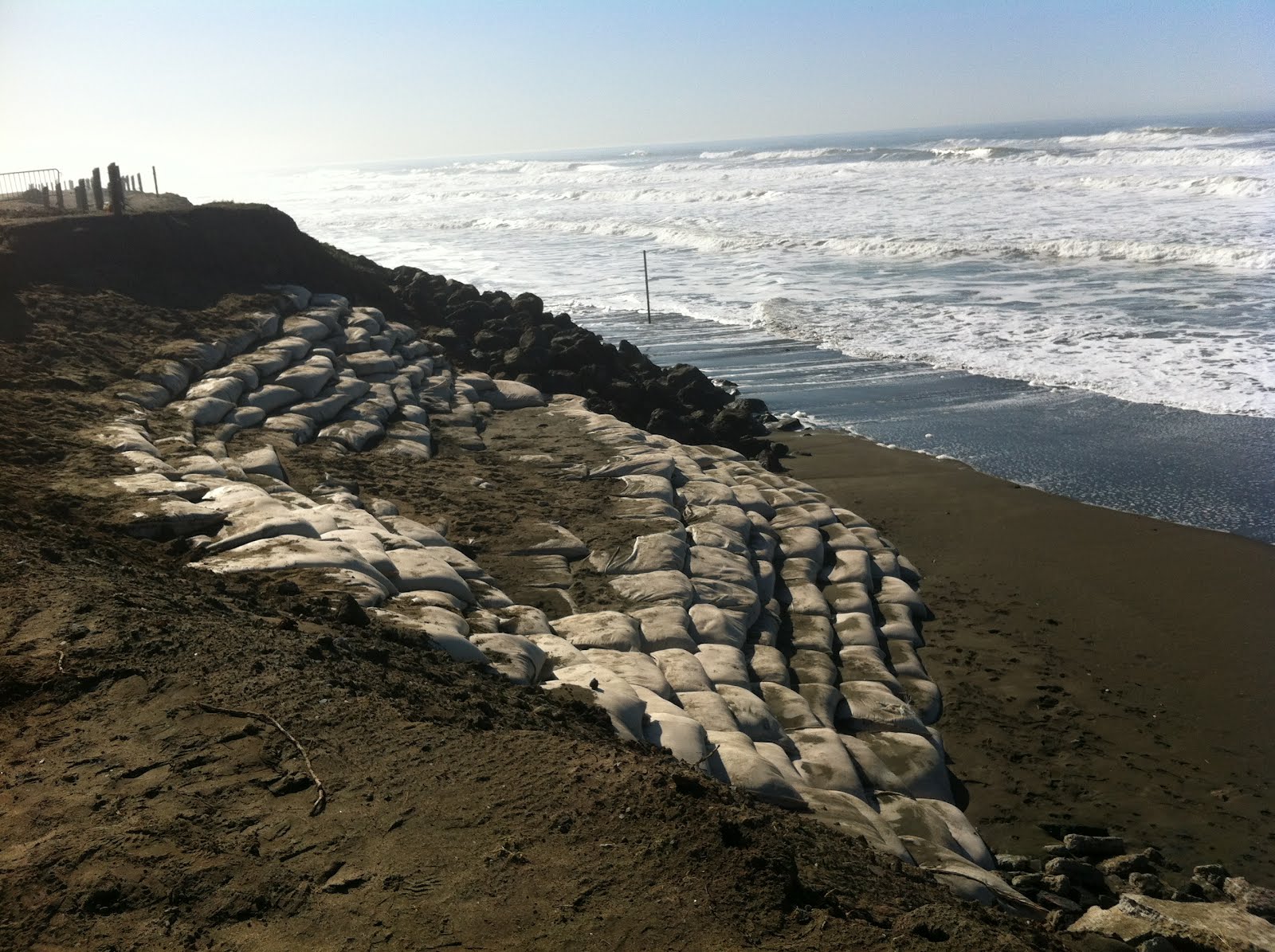
The sandbag work at Sloat's north lot is now complete. Presently, there are no other plans to add sandbags unless we experience an extreme erosion event.

Some folks may wonder what exactly constitutes such an event and when do we get them...

Generally, we get heavy beach erosion when powerful winter storms make a direct hit to our coastline. A direct hit occurs when the core of a system makes landfall bringing with it high surf, strong winds and heavy rain. Here's a little video clip of an erosion producing storm: http://www.youtube.com/watch?v=38R0NvNJG9A&context=C35c902eADOEgsToPDskIEwyjinXyPmvzKBzl2KoP4 The worse erosion for us tends to occur when a direct hit coincides with a large high tide, such as those in the 6.0 ft. range or better. Storms barreling in from the ocean can create a powerful storm surge, allowing the surf to advance much further inland than under fair weather conditions. This allows the sea to chew up or erode whatever lies in its path. Most folks have heard of storm urge associated with hurricane landfall. The storm surge that comes from our winter storms is basically the same thing. Though less dramatic, storm surge from Pacific systems can cause plenty of damage, too, especially when structures have been located too close to the sea.

The good news is that this winter, we appear to be safe. The jet stream, which carries our storm activity, has been positioned well to the north. There has been a bonanza of great weather and surf, and a reprieve for the Sloat shoreline.

In other news, SPUR has secured a grant to do the feasibility analysis for the draft proposal at Sloat. This is great news. We hope to see a full analysis of the low profile tunnel reinforcement concept along with a tunnel relocation/re-alignment option. We are particularly interested in cost/benefit issues (factoring in the value of recreation and ecology). Perhaps some combination of approaches may finally emerge. We certainly believe that any long term plan should include a phase in which the tunnel is removed from the beach.

Finally, SPUR has also extended comment period on the draft Ocean Beach Master Plan. If you have not yet added your input, there is still time. Please visit http://www.spur.org/ocean-beach There are a lot of changes being proposed for the entire beach. It behooves all of us to weigh in. Comment period ends February 29th. Thank you!

Friday, August 12, 2011

Projected Sea Level Rise for Ocean Beach - Why Managed Retreat as a Long Term Strategy


The Future of Ocean Beach? The beach at Sharp Park (Pacifica) is disappearing under a pile of armor. Click photo to see close-up.


Dear Surfriders and Friends,

Many may be surprised to hear that there is a looming threat of beach loss at central Ocean Beach. Below are a few links to scientific reports that have informed this projection. They deal with sea level rise. According to the Pacific Institute report, sea levels off the CA coast have risen 8 inches over the last 100 years. By 2100, sea level rise is predicted to rise another 1.0-1.4 meters (4’-5’). Although sea level rise projections are estimates, the trend lines behind this projection are serious. We should prepare for significant impacts. Middle Ocean Beach has been eroding for some time. We should expect beach loss to continue. However, as compared to Sloat, there is a greater opportunity to slow it down with sand nourishment and strategic sand management practices. This should allow us to buy time for proper planning.

Surfrider believes the sooner we embrace a strategy of Managed Retreat, the better off we will all be – taxpayers, beach users, and ecology. An encroaching high tide line is part of a natural process. If our city chooses to hold fast to existing boundaries, we can expect to see results like we have in the photo above. This is a group of revetments recently placed on the beach at Sharp Park, in the neighboring town of Pacifica. It's not a pretty picture. They are wiping out their beach.

This ia a graphic derived from the statewide study showing the potential erosion by 2100 based on 4.6’ of sea level rise. http://www.pwa-ltd.com/about/about_news.html#OPC_Report

The report by PWA:
http://www.pwa-ltd.com/about/news-CoastalErosion/PWA_OPC_Methods_final.pdf

Here is a link to the Pacific Institute report that this work fed into:
http://www.pacinst.org/reports/sea_level_rise/

Here is the State Adaptation Strategy that was affected by this work:
http://www.climatechange.ca.gov/adaptation/

Monday, August 8, 2011

Our Plan for Erosion Response at Ocean Beach


Greetings Surfriders and Friends,

The SPUR Ocean Beach Master Plan process is currently digesting comments from the Alternatives phase, and beginning to sketch out the Draft Master Plan. Surfrider San Francisco would like to take this time to release our preferred long term solution for Sloat, as well as our general erosion response strategy for Ocean Beach.

While we continue to call for a Managed Retreat solution, we feel it is important to recognize that any long term plan will take years to plan, permit and fund. DPW has asserted that during that time, the sewage transport box under the Great Highway could be exposed, which may cause it to rupture. A break in the box would trigger a sewage spill on Ocean Beach. None of us wants to see this happen. Therefore, our chapter has proposed a practical compromise for our long term plan: We are willing to condone a minimal impact, temporary structure to protect the transport box under specific conditions: It should come as a last resort only to avert a failure of the box, have a limited time span, and only in the context of a Managed Retreat strategy. See below.

We regret that this infrastructure was placed in such a precarious position. It is time to move forward and embrace a practical, commonsense long term plan. Managed Retreat is the best way to preserve our beach and solve the erosion conflict.

A Comprehensive Program of Managed Retreat for Ocean Beach
Surfrider Foundation, San Francisco Chapter’s Official Platform for Sloat Blvd / Ocean Beach Erosion

Summary Statement:

The Surfrider Foundation San Francisco Chapter favors infrastructure relocation and beach restoration as the primary methods to address Ocean Beach’s erosion problems. Sand nourishment is seen as a preferred interim strategy over armoring. Shoreline armoring will cause narrowing and ultimately the loss of the beach. The acceleration of sea level rise is expected to limit the effectiveness of sand nourishment in the latter part of the century, by year 2100. Therefore, retreat and realignment of development is expected to become increasingly important to provide space for the beach to survive. If critical infrastructure (e.g. the transport tunnel) is imminently threatened by erosion, armoring should be employed only as a last resort and a temporary measure in order to give The City time to plan and execute the reconfiguration or relocation of the infrastructure to a more sustainable condition.

We believe separate plans should be pursued for each of the two zones that have erosion issues: One plan for the Sloat Blvd. area / One for Central Ocean Beach. Due to the inherent uncertainty in sea level rise predictions and beach morphology, a fifty year plan, not a one hundred year plan, should first be executed for the two zones. At year thirty of the fifty year plan, an assessment and planning period should commence for both zones that will result in a new fifty year plan.

The Sloat Area: A 50 Year Plan of Managed Retreat
The City should commit to pursuing a Managed Retreat plan for Sloat. During the immediate planning/permitting/financing period of Managed Retreat, a small, temporary revetment (5ft high) could serve to protect the transport tunnel by stabilizing the toe of the bluff. Further temporary safeguarding of the tunnel may be achieved through interior reinforcement.

We are calling for a Managed Retreat plan that encompasses the following:

1. Re-route the Lake Merced Transport Tunnel and the connections from the Westside Transport Box and Pump Station so that they enter through the back side of the treatment plant. The southern section of the Westside Transport Box may also require modification to reduce the potential for exposure and loss of beach.

2. Re-route the Great Highway around the backside of the zoo.

3. Relocate Sloat’s North Parking Lot and bathroom facilities eastward from the current location to the area immediately in front of the Westside Pump Station.

4. Eliminate the Muni Bus turnaround.

5. At the south end of the affected area, relocate the south parking lot to the endpoint of the Great Highway (just before the intersection at Skyline Boulevard).

6. When opportunistic sand is available for beach nourishment, begin removal of all quarry stone revetments and rubble now littering the beach and construct a large sand berm to serve as a protective barrier for the entire area. Strengthen the dune with native plants, install sand ladder access trails, and construct a bike/walking path on the eastern side of the restored dune.

7. A plan for monitoring the new berm, as well as a plan for periodic sand nourishment should be in in place upon completion of the project.

With this strategy, the wastewater plant should have sufficient protection at its current location until its 100 year life cycle is completed. (Approximately 80 years remain).

Worst Case Scenario: If the new sand berm is severely eroded and the high tide line advances to a predefined point of emergency status at anywhere along the 3 reaches that include the pump station, zoo or the wastewater plant, then temporary armoring would be condoned only under the explicit condition to give the City time to plan and execute a relocation/reconfiguration of these structures. When complete, the temporary armor should then be removed and the beach returned to its natural state. There should be a formal mechanism to ensure future removal of any armoring.

Central Ocean Beach: A 50 Year Plan
For the next 50 years: A plan for monitoring erosion as well as aggressive sand dune nourishment/placement should be implemented along Central Ocean Beach. Nourishment areas would be identified as locations in which the high tide line has reached a certain distance from the seawall or road. As in the case of the Sloat area, a reassessment and planning period should occur at year 30. If at that time, if the beach is significantly narrower than when the first 50 year plan started, then planning should commence for the relocation of the Great Highway and the rest of the westside transport box.

Conclusion:
At Sloat, with infrastructure relocation and a renovated sand berm free of debris, the public and The City have a win-win solution. Infrastructure is protected and the public’s sandy shoreline/beach is preserved. At Central Ocean Beach, continual monitoring and timely sand nourishment should preclude the need for new armoring as well as give us the time we need to better evaluate sea level rise rates and beach morphology data. This plan does allow for flexibility if the high tide line moves inland to the point of threatening the remaining infrastructure. In such cases, temporary armoring is condoned as an emergency action under the express purpose to give The City time to relocate that infrastructure away from the ocean.

Wednesday, March 9, 2011

Ocean Beach Erosion Article on SFGate / SF Chronicle


The new revetment looking south. Photo taken 3/21/11 4:35pm Tide apprx. 3.2ft

Greetings Surfriders and Friends,

Last Friday March 4th, there was a front page article about erosion at Ocean Beach that featured the problem at Sloat. It also appeared Sunday March 6 in SFgate. Here's a link to the online version...

http://www.sfgate.com/cgi-bin/article.cgi?f=/c/a/2011/03/04/MNGM1I1O92.DTL

The article was well written, providing a great synopsis of the issues involved as well as where we right now in the process of finding a long term solution.

One important comment: The article seems to suggest that Coastal Armoring, Managed Retreat and Sand Nourishment are separate, mutually exclusive erosion control solutions for Sloat. They are not. We beleve in a sensible combination of strategies that emphasizes more of the last 2 methods: Managed Retreat and Sand Nourishment. Our vision consists of moving the parking lots, the road, and the wastewater tunnel out of harm's way. Then, a large sand dune (via sand nourishment) should be constructed in its place. With a sand barrier, we have an erosion control system that allows for the restoration of the public's beach and safer access to the shoreline. Look for more details to emerge on Managed Retreat as we head into the next phase of the Ocean Beach Master Plan - Alternative Solutions.

Thursday, February 24, 2011

Ocean Beach Master Plan Open House at the Park Chalet


Just in case you missed the SPUR workshop at the zoo January 15, there will be another chance for the public to review and comment on the Ocean Beach Master Plan. On Saturday March 5, from 10am - 12noon, the Park Chalet will host the workshop material. All folks that want to see our beach restored at Sloat are urged to weigh in at all SPUR workshops. In addition to the Sloat issue, there are other important issues getting addressed in the Master Plan: restrooms, bike paths, garbage collection, native plant restoration efforts, etc. Feel free to bring the family has there will be free root beer and facepainting for the kids. Thanks to Lara Truppelli of the Park Chalet and SandOB for sponsoring this event.

Monday, February 1, 2010

Safety Reminder - Please stay off the bluffs

DPW has asked me to pass along a safety reminder. Please give the bluffs, even the areas that have not yet fallen into the ocean, a healthy safety distance. I just read the book Death in Yosemite which dedicates a chapter to people falling off cliffs; let's keep in mind our human ability to eyeball safety is fairly flawed.

Independent of your own personal safety is the stability of the bluff itself. Walking on, around, and underneath the bluff disturbs the soil directly, and potentially of greater importance, the paths in which runoff flows. The rain and waves are already challenging enough for the delicate bluffs without the additional disturbances.

Please stay off the bluffs.

Thursday, January 28, 2010

SF Surfrider Press Release.


FOR IMMEDIATE RELEASE

Contact:

Darin Rosas

SF Surfrider Chair

darin@sfsurfrider.org

http://sloaterosionob.blogspot.com/


THE SAN FRANCISCO SURFRIDER FOUNDATION ADDRESSES COASTAL EROSION EMERGENCY AT OCEAN BEACH IN SAN FRANCISCO

San Francisco, CA (January 22, 2010) – The San Francisco Surfrider Chapter (SF Surfrider) is calling for a long-term solution to the coastal erosion problems at Ocean Beach, SF, south of Sloat Blvd. This comes in response to a declaration of a coastal erosion emergency, by the SF Department of Public Works (DPW), along the shoreline south of Sloat Boulevard

On January 7th the southbound lane of the Great Highway, south of Sloat Boulevard was closed and, on January 21st, both southbound lanes were closed. On January 15th, the DPW announced a declaration of emergency along the Great Highway due to severely eroded bluffs on the west side of the road. Currently, most of the Great Highway from Lake Merced to Golden Gate Park is closed due to a storm. Only the bus turn-around at Sloat Boulevard is open.

In recent years, the DPW has used beach nourishment to control the coastal erosion issues at Sloat Boulevard. SF Surfrider understands the need for taking emergency action to protect the current infrastructure along the Great Highway, south of Sloat Boulevard. However, SF Surfrider feels that a long-term solution is overdue.

In 2001, the Ocean Beach Taskforce, created by Mayor Willie Brown, analyzed alternate solutions for coastal erosion issues at Ocean Beach. The Taskforce concluded that the best long-term solution was a combination of beach restoration, managed retreat, and infrastructure relocation. No official long-term policy was ever adopted or executed.

Surfrider Foundation advocates long-term solutions where coastal development is threatened and suggests the goal of maximizing beach access while minimizing impacts to the beach and its ecological integrity. Under no circumstances does SF Surfrider support the permanent installation of hard retention structures along the coastline. Such structures can temporarily protect existing coastline development but have no place in beach preservation or a healthy beach ecosystem.

A community meeting is being held on Monday, January 25th at 7pm at the Park Chalet (located behind the Beach Chalet at 1000 Great Highway in San Francisco) to discuss the proposed actions at Sloat Boulevard. The DPW Project Manager, Frank Filice will be there to discuss the emergency declaration, the short-term strategy, and a process for a long-term solution.

Everyone who has an interest in the preservation and the future of Ocean Beach is encouraged to attend. The emergency declaration will go before the San Francisco Board of Supervisors for ratification the following day, Tuesday, January 26th. For questions or more information, please email the meeting organizer and Chair of the San Francisco Ocean Beach Vision Council: Lara Truppelli at Lara@beachchalet.com.

______________________________

The Surfrider Foundation, San Francisco Chapter
is a non-profit grassroots environmental organization dedicated to the protection and enjoyment of our world’s oceans, waves and beaches. Now in its 26th year, the Surfrider Foundation has grown from a small group of dedicated surfers in Malibu, California to a global movement made up of over 50,000 members and 90 chapters worldwide. For more information visit us at www.sfsurfrider.org.

###

Tuesday, January 26, 2010

2005 Storm Damage Protection Project Report

So I went through the 2005 Storm Damage Protection Project Report for the USACE and SF DPW (thanks to DPW for the posting it) and it gives a better overview of the shore protection problem up to 2005. I summarized a few of my favorite points: points that may shed light on 2010’s problem, but I encourage you to download the report and skim it yourself.

My Favorites Points:

The description of the different interests involved: pulling apart the road, from the lots, from the outfall pipe, from the Merced Transport pipe, from the bluffs. An outline of the interests on page 2-26 was originally by the SF Parks and Recreation Dept in 2002. The public discussion in 2010 often lumps all the interests together so it becomes difficult to weigh the cost/benefit and scope of different solutions.

Figure 3-3 on page 53 of the *.pdf shows a diagram of the most recent rip rap placement (referred to as Emergency Quarrystone Revetment) between first and second lots.

Moffatt and Nichol’s 1995 description of the coastal morphology starting on page 3-13. It indicates the the south lot area’s sand source is derived largely from the bluffs, and goes over seasonal reversals based on the wave climate.

Just like today: USACE (and other by CH2M Hill) 1996 study included the scenario where the lots were eroded and the Merced Transport box was threatened. The summary of this report is brief, but the area of the 1996 study appears to be further north in way of the lots, rather than just south of the outfall pipe where is 2010’s problem is. It gives a 22% chance of damage to the Merced Transport box, but it’s unclear if that is on a “per year” or “per storm” or what the relevant time scale is once the roadside has been reached. See page 3-16.

CH2M Hill reports that the southern reaches show large fluctuations in the area of the shoreline on page 3-25, and subsequent plots by Moffatt and Nichol show very large fluctuations of the shoreline of up to 100 to 150 feet.

Comic relief: When discussing constraints of different alternatives on 4-15, it notes that gorillas displays aggressive behavior during noisy earthwork. It’s tough to imagine a project with more exotic constraints.

Preferred alternatives are identified by each stakeholder on page 5-6. In 2005, as in 2010, the DPW prefers a hard structure over other alternatives for its lower maintenance cost.

Quoting from the discussion of acceptable alternatives on page 5-8, “SFPUC could not support any of the options that would result in the loss of the traffic lanes and possible exposure or loss of cover to the Lake Merced Transport facilities. The north bound traffic lane is important to the SFPUC as a means of access to the Oceanside WPCP. The northbound lane is also important in case of emergency in order to have two means of egress out of the WPCP facility. There is also concern that if the cover on the Lake Merced Transport is reduced there could be issues with structural stability or buoyancy effects.” The 2010 discussion has focused on the DPW’s interests; I’m curious as to why the PUC did not bring their interests to the public debate when the northbound lanes first closed. (Perhaps PUC is satified with the alternate routes onto Harding Rd and Armory Way and no longer considers Great Highway critical.) In 2005, DPW needed anything besides “no action.”

A stakeholder agency workshop held in 2005 gave all the agencies a chance to look at various alternatives. The DPW’s acceptable solutions listed on 5-12 include nearshore sand placement (which was the strategy adopted) and hard structures on the existing (then existing?) shoreline, presumablely for their lower maintenance cost. The SFPUC was willing to try anything that did not involve facilitated retreat or doing nothing. Each agency’s conclusions are summarized in a chart on 5-15.

Sunday, January 24, 2010

save sloat.

photo by sf surfrider

1.24.10

photo by sf surfrider

photo by sf surfrider

photo by sf surfrider

photo by k. riccitiello

photo by k. riccitiello

photo by k. riccitiello

photo by k. riccitiello

Thursday, January 21, 2010

Wednesday, January 20, 2010

both southbound lanes closed on the great highway.

San Francisco DPW closed both southbound lanes of the Great Highway south of Sloat Blvd.

http://www.sfgate.com/cgi-bin/article.cgi?f=/c/a/2010/01/20/BANC1BL3DQ.DTL

This article references a 1996 Army Corps of Engineer Report that suggested coastal armoring at Sloat -- this was PRE-Ocean Beach Taskforce, which eventually lead to an Army Corps of Engineer Project that helped renourish Ocean Beach at Sloat Blvd.

The Army Corps of Engineer Project places sand annually that is dredged from the main ship channel into San Francisco Bay in the coastal zone offshore at Sloat Blvd. The goal is to deposit sand in the near-shore location that will work its way onto the shoreline and build up the width of Ocean Beach at Sloat Blvd.

More info on the Army Corps of Enginner Project at Sloat:
http://www.spn.usace.army.mil/newsrelease/newsrelease_5_21_09_SF_Ocean_Beach.html